


Orbital: Revolutionizing Oil Spill Monitoring

Dear Space Community,
Happy to share the interview with Juan Peña Ibáñez, CEO & Cofounder at Orbital. Juan shares insights into their cutting-edge oil spill monitoring solution, which has transformed how oil spills are detected, tracked, and managed. With a foundation in extensive experience from the Spanish Coast Guard, Orbital has created a platform that combines AI, satellite technology, and predictive modeling to offer unparalleled efficiency and accuracy. From proactive surveillance to identifying sources of pollution, Orbital provides a comprehensive solution for environmental protection in some of the world’s most vulnerable marine regions.
What differentiates Orbital’s oil spill monitoring solution from other methods used in the industry?
Orbital’s oil spill monitoring solution was developed by our founding team, which has over 30 years of experience in operational oil spill monitoring with the Spanish Coast Guard. Our solution offers a 10-20x increase in cost efficiency compared to traditional surveillance methods that rely on vessels, helicopters, or airplanes.
Additionally, our platform includes the capability to run oil spill trajectory forecasting. These models use the precise shape and characteristics of the spill as detected in satellite images, resulting in significantly more accurate predictions.
Can you elaborate on the specific types of radar and optical satellites your system utilizes for oil spill detection?
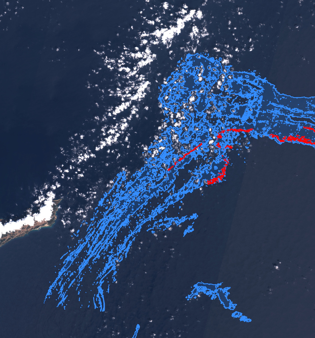
We currently work with a portfolio of over 60 satellites. The combination of different satellites enhances the system’s flexibility and adaptability, while also improving accuracy since each sensor type has its own strengths and limitations.
Synthetic Aperture Radar (SAR) sensors provide all-weather, all-time capabilities, as they can operate at night and through clouds. On the other hand, optical sensors allow us to quantify oil spills and detect them in more challenging conditions, such as low wind or areas near the coast where SAR may not perform as well.
How does Orbital ensure the accuracy and timeliness of data received from satellite networks?
To ensure the accuracy of our detections, we conducted a six-month validation campaign in collaboration with the Fujairah Research Center (FRC) in the UAE.
During this campaign, satellite detections reported by Orbital in UAE waters were verified by FRC using vessels to collect on-site photos and samples. Following this process, we demonstrated an overall accuracy exceeding 90%.
Regarding timeliness, we utilize specialized software to plan satellite acquisitions over designated areas, along with automation and AI to analyze images almost in real-time. Since 2019, we have supported multiple oil spill emergencies, delivering timely information to our clients to enhance their decision-making processes.

What image processing and analysis techniques are employed by Orbital to identify and monitor oil spills effectively?
Our approach is rooted in both the fundamental physics of how oil behaves on the sea surface and our extensive experience in remote sensing. We’ve pioneered the development of an AI model that delivers performance comparable to that of a human expert in detecting oil spills in satellite imagery.
Additionally, we incorporate AIS data into the analysis, which allows us to identify vessels responsible for illegal oil discharges, ensuring these violations don´t go unnoticed.
How does Orbital’s system promote proactive oil spill surveillance, and what are the benefits of this approach?
Orbital’s system allows for continuous and real-time satellite monitoring, enabling the detection of oil spills even in their early stages. This proactive approach helps prevent spills from escalating into larger environmental disasters. By identifying spills sooner, authorities and companies can respond quickly, minimizing environmental damage, reducing cleanup costs, and mitigating reputational risks. Our platform also offers the ability to forecast the movement of spills, providing a critical advantage in preparing containment strategies and avoiding further contamination of sensitive coastal areas.
How does your user-friendly interface facilitate oil spill monitoring, particularly for those without extensive remote sensing expertise?
Our platform is designed with a user-friendly interface that simplifies complex satellite data, making it accessible to users without remote sensing expertise. With intuitive dashboards, clear visualizations, and automated reports, users can easily interpret data and make informed decisions. The platform also offers real-time alerts and integrates additional data, like AIS, to provide a complete picture of the situation. This ease of use enables quicker decision-making in critical moments and empowers a broader range of stakeholders, from environmental agencies to corporate teams, to engage in effective oil spill monitoring.
Can you provide examples of successful cases where Orbital’s service has been used to detect and respond to oil spills?
We are currently working with the government of Saudi Arabia on the regular monitoring of the Red Sea and Arabian Gulf. This system is the most advanced in the world in terms of coverage and frequency, allowing for prompt detection of oil spills and rapid response, significantly minimizing environmental risks.
Recently, we also assisted authorities in Oman during an emergency following the capsizing of an oil tanker in Omani waters. Our satellite technology enabled quick detection and assessment of the spill, which supported the authorities in managing the crisis effectively.
In the UAE, our collaboration with the Port of Fujairah has led to the successful detection of illicit oil discharges. Our satellite monitoring system helped identify the responsible vessels, providing crucial evidence for enforcement actions.
Our solutions have also proven critical during oil spill emergencies in Europe and South America, where we provided timely and accurate data that helped organizations minimize environmental impact and reputational damage.
What types of reports or insights does Orbital offer to clients using its oil spill monitoring solution?
Orbital provides comprehensive reports that include detailed satellite imagery, spill characterization, and the exact location and shape of the detected oil. Our reports also offer a confidence level assessment, which can be used in legal cases or compliance reports. In addition to this, we provide trajectory forecasting, which predicts the movement of the spill based on real-time data. Clients also receive information on potential sources of the spill, including vessel identification through AIS integration. These insights help clients not only respond to incidents but also support long-term monitoring and compliance strategies.
What are the key challenges faced by the oil and gas industry in oil spill monitoring in the GCC, and how does Orbital address these?
The GCC region presents unique challenges for oil spill monitoring, including the vast maritime territories, high density of maritime traffic—particularly oil tankers—and extensive offshore oil production areas. These factors, combined with a complex geopolitical environment, significantly increase the risk of large-scale or catastrophic oil spills across many countries in the region.
Orbital addresses these challenges by leveraging satellite technology capable of monitoring large areas efficiently and continuously. Our combination of SAR and optical sensors ensures all-weather, day-and-night detection capabilities, crucial for such high-risk zones. In addition, our AI-driven analysis processes data quickly, allowing us to provide near real-time information to clients, which is essential for timely responses. By integrating AIS data, we also help identify potential culprits of illegal discharges, enabling swift enforcement actions. Our solutions provide a robust framework to monitor high-risk environments and mitigate the impact of oil spills in such a complex region.
How does Orbital envision the future of oil spill monitoring technology, and what advancements are on the horizon for your company?
At Orbital, we believe the future of oil spill monitoring will be shaped by increasing automation, predictive capabilities, and global coverage. We see a growing role for AI-driven analysis, where algorithms will not only detect spills more accurately but also predict potential spill risks based on maritime traffic, environmental conditions, and historical data. This will allow for preventive actions rather than just reactive measures.
One of the key advancements on the horizon for Orbital is expanding our system’s integration with more environmental factors, such as wind and current data, to enhance the precision of oil spill trajectory forecasting. We are also working on further enhancing the speed and efficiency of data processing to deliver real-time alerts and insights even faster.
Additionally, we envision expanding our global monitoring network to cover even more regions at higher frequencies, providing comprehensive coverage in areas of high risk. Our goal is to continue developing the most advanced, automated, and reliable oil spill monitoring systems in the world, empowering stakeholders to protect marine environments proactively.
You can request more info via info@orbitaleos.com